Introduction to Landsat Remote Sensing Satellites
The Landsat Series - Multispectral Scanners - Thematic Mappers - Australian Data - Web Links
Landsat Remote Sensing Satellites
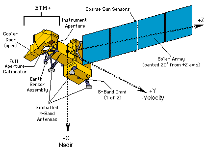
The first Landsat satellite was launched as an experiment in July 1972. It returned information of unforeseen value. The Landsat series of remote sensing satellites was developed as result. Each new satellite has continued to improve its sensing capabilities and build upon the success of the initial mission.The Landsat Project Office at Goddard, Maryland developed and launched the Landsat 7 satellite and developed the ground operations system. In October 2000, the U.S. Geological Survey assumed operation of the spacecraft.
More information:
![]() USGS overview of the Landsat Program
USGS overview of the Landsat Program
![]() Landsat operation and data set details
Landsat operation and data set details
| Satellite | Launched | Notes |
| Landsat 1 | 1972 | Decommissioned 6 January 1978 |
| Landsat 2 | 1975 | Decommissioned 25 February 1982 |
| Landsat 3 | 1978 | Decommissioned 31 March 1983 |
| Landsat 4 | 1982 | Satellite turned off in August 1992 and kept in standby mode |
| Landsat 5 | 1984 | Operational |
| Landsat 6 | 1993 | Failed on launch |
| Landsat 7 | 1999 | Operational |
