 Part 6 of 8


The Ultimate Field Trip
An Astronaut's View of Earth
by Kathryn D. Sullivan, Ph.D.
NASA Astronaut

|
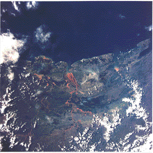
Soil Erosion [STS029-84-040]
Deforestation exposes land to soil erosion. Heavy rains pick up the topsoil and carry it
downstream to deposit it in the estuary. Here the Betsiboka River
deposits sediment from deforested areas of northwestern Madagascar
into the Bay of Bombetoka. We in already developed parts of the
world may decry the environmental damage caused by this primitive
form of development. But, as Kathy Sullivan suggests, North America
might have looked much the same during its 19th-century development
if one could have seen it from the same vantage point, 150 miles
up.
|
Many people imagine that Earth would appear an idyllic
place from this vantage point, that all signs of strife and conflict
would vanish, and that the true unity of our planet and species
would be evident. Sadly, this is not so. The world contains
an abundant population of human beings, and our planet bears many
signs of people's actions that are visible from orbit.
I find the sight of national boundaries we've drawn between
ourselves especially striking. Some of these lines reflect wars
and continuing disputes (the Arab-Israeli treaty boundary of 1979,
the Angola-Namibia border). Others are visible simply because
adjacent countries divide their agricultural lands differently,
creating subtly different patterns that the human eye and brain
are quite adept at distinguishing. Examples of this are the borders
of the United States with Canada and with Mexico or the border
between Brazil and Paraguay.
Other signs of human population and activity are more worrisome,
thrusting upon us daunting, intertwined questions of national
sovereignty, natural resource utilization, and social development,
even as we race by at 5 miles per second. Most of the once-lush
Madagascan rain forest is now gone, and the resulting soil erosion
chokes the rivers with immense loads of sediment.

|
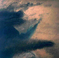
Kuwaiti Oil Field Fires [STS039-72-060]
In this photo, taken by the crew of STS-39 in April of 1991, we can see that
firefighters have had some success in extinguishing oil well fires
ignited during the Persian Gulf War. In this view looking south
from the delta of the combined Tigris and Euphrates Rivers, only
a few of the fires in the patches at the top of the picture are
still burning. The picture also indicates the pollution problems
that will be left even after all the fires are put out: ponds
of unburned oil, soot deposits on the sand, and air pollution.
This acute pollution incident is a dramatic illustration of the
chronic pollution of the Earth's atmosphere by our automobiles,
power plants, and forest burning.
|

|
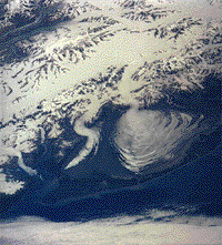
Malaspina Glacier [STS028-97-082]
Malaspina Glacier, on the southeastern coastof Alaska, shows the difference between alpine and piedmont glaciers in graphic fashion: Alpine glaciers, confined in mountain valleys,
are linear rivers of ice. Piedmont glaciers spread out onto plains
as sheets of ice. Here we see a confined river of ice emerging
onto the coastal flats and widening dramatically. The black material
is rocky moraine ripped by the ice from the valley walls and floor.
In the confining valleys, these moraines appear as straight black
stripes. As the ice spreads out on the unconfined flats, these
black stripes are pulled sideways into zigzags. In the present
warm, "interglacial" times, most glaciers have retreated
way back up their host valleys to nestle near the mountain peaks,
where the snow supply is still abundant. During the ice ages,
many glaciers grew so large they flowed down the entire length
of the valleys, becoming vast sheets of ice on the continental
plains below.
|
What will happen to the people there? What will be the
fate of the island's unique populations of rare birds, other
animals, and plants? In South America, large regional developments
expand into the Amazon Basin rain forest. Will this be the end
of the Earth's great rain forests? Will their loss harm
our global environment in permanent ways? How do we find better
solutions to the very real social and economic issues propelling
the developments in these countries? And, finally, wouldn't
North America have looked very much like this, if I could have
orbited overhead in the 19th century? What did my home continent
look like way back then? What were the effects of North American
development? The hallmark of a good educational experience:
I'm left with far more questions than answers!
I suspect it will be many years before Earth-observing
rides in space are generally available. In the meantime, what
sorts of people will continue to explore this vast frontier?

|
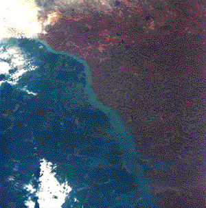
Paraguay-Brazil Border [STS61A-32-087]
A difference in land use policy between Paraguay and Brazil is apparent in this
Shuttle view of their boundary. The extensive forest clearing
and agricultural development on the Brazil side of the river contrast
sharply with the forested area and clumps of fields on the Paraguay
side. You can see silt brightening the headwaters of at least
two of the tributaries from Brazil but no similar signs of soil
erosion from Paraguay.
|

 Part 6


Recommended citation (MLA-Style): Sullivan, K. D. 9 August 1995. "The Ultimate
Field Trip: An Astronaut's View of Earth, page 6" Earth Observations and Imaging Newsletter,
Office of Earth Sciences, NASA Johnson Space Center. <http://eol.jsc.nasa.gov
/newsletter/uft/uft6.html>
This local copy was downloaded from
http://eol.jsc.nasa.gov/newsletter/uft/uft1.html on 18 Jan 2000.
Notices: What You Need to Know About NASA JSC Web Policies
Responsible NASA official: Dr. Kamlesh Lulla
Curator: James Heydorn

 Part 6 of 8


 Part 6 of 8


 Part 6

