
 Part 5 of 8

 Part 5 of 8
 |
 |
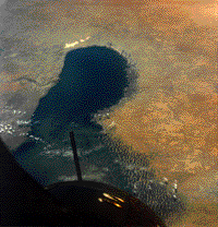
Photographed from Gemini, the full lake measured 22 000 km2. |
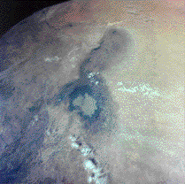
Photographed from STS-41, the drought-plagued lake was reduced to the light patch in its southern part (1600 km2). |
The results of this effort were a color-coded map showing the growth of the Great Salt Lake from 1973 to 1985 and calculated values for the lake surface area in each year. These figures were compared with ground measurements of the lake made by the U.S. Geological Survey each year, using standard field-surveying techniques. The calculations made from the Shuttle photographs were found to be in excellent agreement (±3–6%) with the ground data. Now that the technique is proven, it is being applied to more remote sites, such as the Lake Chad Basin and Omo River Delta regions of Africa. Ground survey data are limited in such remote areas, but the amount of water and vegetation are critical indicators of drought conditions. The ability to determine these conditions for an entire region with satellite and Shuttle data provides a valuable tool to the national and international agencies involved in drought monitoring and relief efforts.
Part 5
This local copy was downloaded from http://eol.jsc.nasa.gov/newsletter/uft/uft1.html on 18 Jan 2000.
Responsible NASA official: Dr. Kamlesh Lulla