
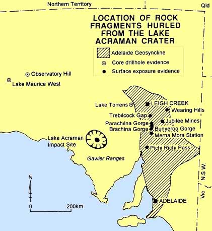
Scientific detective work during 1983 by geologist Dr Vic Gostin and his colleagues revealed a surprisingly continuous layer of volcanic rock debris throughout much of the Flinders Ranges. The layer ranges in thickness from 0.4m in Brachina Gorge, where rock fragments are up to 0.3m across, to only a few tens of millimetres in the Wearing Hills 100km to the east, where the rock fragments are the size of coarse sand. The thinning of the layer and decrease in size of the fragments towards the east suggested that the debris had its origins in the west.
The fragments are of similar composition to volcanic rocks found in the Gawler Ranges, hundreds of kilometres to the west on Eyre Peninsula. Even more intriguing is the age of the rock fragments - 1,575 million years - and this within sedimentary rocks that were deposited only 600 million years ago.
Another Adelaide geologist, Dr George Williams, suspecting he had the answer to this puzzle, examined newly available satellite pictures of Eyre Peninsula. In 1985 he found that Lake Acraman, a lonely salt lake in remote northern Eyre Peninsula, is surrounded by a series of concentric rings ranging in diameter from 30km to almost 160km. He knew that rock samples from the lake contained structures known as shatter cones, and microscopic examination of the rock had revealed irrefutable evidence of intense shock deformation. The jigsaw could now be reassembled and the complete picture revealed.
Approximately 600 million years ago, sediments of the present Flinders and Mount Lofty Ranges were being deposited in a shallow sea that covered much of eastern and north-western South Australia; Eyre Peninsula as we know it, with its very much older rocks, was above sea level. At that time an extraterrestrial object - asteroid, comet or meteorite - approximately 4km in diameter and travelling at almost 100,000 km/hour, plunged into ancient volcanic rocks of tbe Gawler Ranges. The immense force of the collision blasted a crater at least 30km wide and several kilometres deep. Rock not vaporised was hurled outwards at velocities several times the speed of sound, to splash down in shallow seas at least 500km away. Finer material and dust blown into the upper atmosphere probably took months to settle back to earth.
In the hundreds of millions of years that followed, this debris layer
was buried by thousands of metres of marine sediments, folded then
uplifted during development of the Flinders Ranges and, finally,
re-exposed by weathering and erosion.
At the Lake Acraman impact site, only the very roots of the crater remain below the level of the original crater floor - testimony to an immense explosion in South Australia before the Flinders Ranges existed.
In the Landsat mosaic at right, Lake Acraman is the circular lake
on the lower left hand side. The Flinders Ranges are the dark xxx
on the upper left hand side.
Click the mosaic for a higher resolution image.
The mosaic was constructed from the following relatively cloud free
Scenes taken by the Landsat 7 spacecraft:
Source of text and map: Baker, Sue, McGaskill, Murray and Ward, Brian J., (eds),
Explore the Flinders Ranges, Royal Geographical Society of Australia,
SA Branch Inc, ISBN 0 909112 18 5
100081 2000 05 31
100082 2000 02 25
099081 2000 07 11
099082 2000 07 27
098081 2000 07 04
098982 2000 07 20
Source:
Australian Centre for Remote Earth Sensing (ACRES)